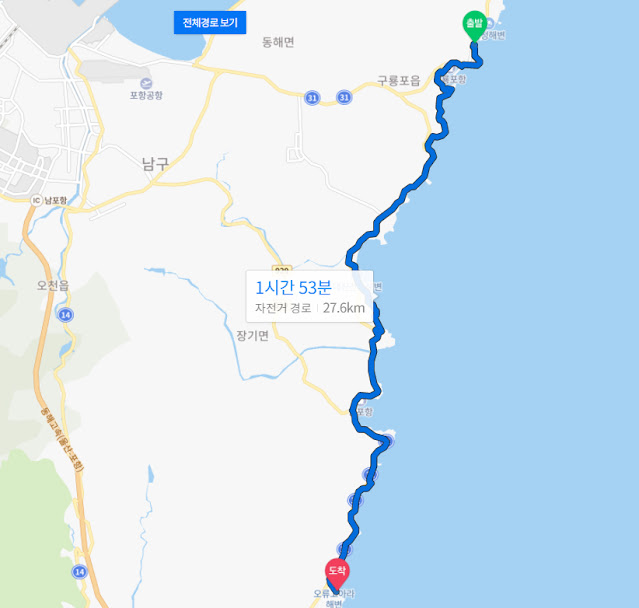
Here are the route maps for each segment of what's going to be a 26-day (therefore 26-segment) trip down South Korea's east coast. The route you see was mapped on cyclists' paths; had I used the "walk" mode on Naver Map, I'd have gotten different results. Whether this path actually follows the official east-coast Gukto Jongju, I can't say. I'll know when I walk it. At the very least, though, I have a good idea of what path I'll be walking, and as it turns out, the east coast is so built up that there is no shortage of hotels, motels, and pensions for me to stay at, so I won't need my backpack. (If you're exclusively a reader of this blog, then you don't know that, on May 14, I suffered a stroke and was in the hospital for a week. I've been recovering ever since; my walking is almost back to normal after a bit more than a month, and I now routinely do the 18K walk from Bundang's Jeongja Station back to my apartment. Since being in the hospital, I've lost a backpack's worth of weight, so it's almost a shame I won't be using a backpack this year.)
Anyway, here are the maps. Enjoy. (Click to enlarge.)
Leg 1:
Leg 2:
Leg 3:
Leg 4:
Leg 5:
Leg 6:
Leg 7:
Leg 8:
Leg 9:
Leg 10:
Leg 11:
Leg 12:
Leg 13:
Leg 14:
Leg 15:
Leg 16:
Leg 17:
Leg 18:
Leg 19:
Leg 20:
Leg 21:
Leg 22:
Leg 23:
Leg 24:
Leg 25:
Leg 26:
So there you have it. The last few legs look awful because they take me across land instead of following a coastal path. But who knows? Maybe it'll be a nice walk all the same. Note that the times listed in blue font on each map are, with only a few exceptions (a few of the routes were plotted in "walk" mode), for cyclists, not walkers, so just concentrate on the distances and assume I'm walking about 4 kilometers an hour (maybe less, especially toward the end, but you'll recall that I usually tend to walk faster on the final day). Will there be changes to the above route? I don't know. Maybe, especially if something dire happens along the path. Otherwise, that's what I've mapped out, so that's basically the route I'll be walking. It doesn't all follow the coast, as you see; sometimes the path swings away from the ocean. But that's to be expected; bike paths don't move in straight lines.
I'm still not sure how much I'm going to like the coastal experience. My two-day reconnoiter didn't feel promising, and I get the sense that it's going to smell like fish the entire way down. Not looking forward to that, although there's a chance I might get used to it.
Korea has other coastal paths to explore as well: there's the short south-coast route as well as the west coast route to do, but I'm pretty sure my first love will be my truest love: the riverlands. I'll get back there eventually, and with my friend JW as my hiking partner, we'll do segments of the riverlands during the off-seasons as we can. So there's no reason to mope, and every reason to keep exploring. Had it not been for my recent stroke, I'd have taken some vacation time to hike to the Andong Dam, and I still might do that later this year after I'm back from the coastal walk and before things get too cold. Korea may be small, but it has plenty of paths to explore.


